 Background, Objectives & Process
Background & Planning Context
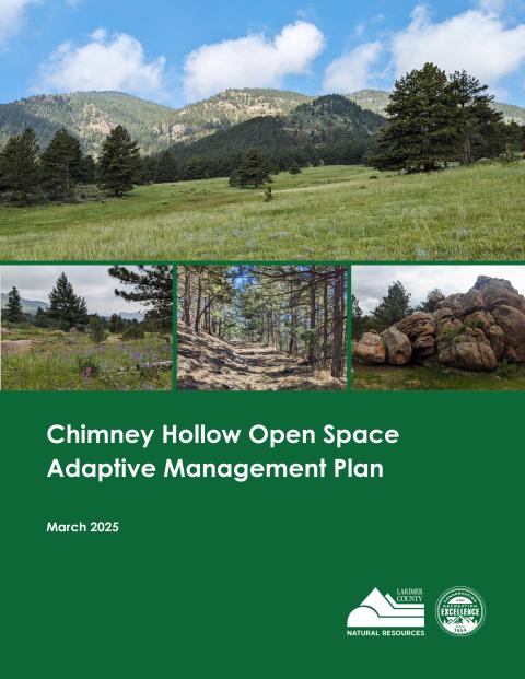
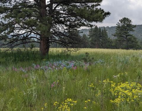
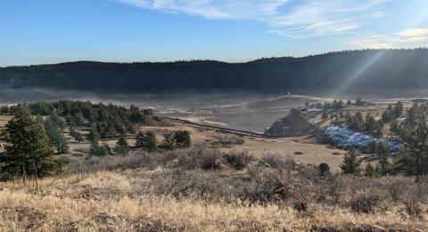
The approximately 3,400-acre Chimney Hollow Open Space (CHOS) was originally acquired in 2004 in partnership between Larimer County Department of Natural Resources (LCDNR), which purchased 1,847 acres, and Northern Colorado Water Conservancy District (Northern Water), which purchased an adjacent 1,600 acres for a new reservoir. Located west of the City of Loveland, CHOS is part of the Blue Mountain Conservation Area, a network of other conserved lands including conservation easements on private lands and public land including the Bureau of Reclamation’s Carter Lake and Flatiron reservoirs. Within this context, this management plan is intended to outline the long-term management of CHOS to ensure enhancement of ecological resources and provide appropriate nature-based public access.
Since first acquired, management of CHOS has been guided by the Chimney Hollow Open Space Stewardship Plan (2005),(Appendix A) which remains a foundational document on which this current effort builds. The 2005 plan contains important information including the historical background of the area and baseline information about climate, topography, geology, vegetation, and cultural resources. It also includes adopted management zones to identify appropriate use of certain areas of the open space. The zones identified include developed, front country, backcountry, and primitive. The intent of this zoning will be carried forward into this plan.
In 2023, LCDNR conducted a random-sampled, statistically valid, county-wide survey in partnership with seven municipalities within Larimer County to help inform future management by gathering data on the communities’ preferences for land conservation, nature-based recreation and perceptions of crowding. The full report for the effort, titled Our Lands Our Future, is available online. This updated information about visitor preferences, growing population and associated demand for outdoor recreation, and changing ecological conditions have helped provide a framework to consider management actions at CHOS. With key objectives to provide a quality nature-based visitor experience, protect and enhance natural resource values, and maintain fiscal sustainability, this plan includes short-term infrastructure development recommendations as well as recommended adaptive management approaches and criteria for managing CHOS into the future.
Plan Objectives & Adaptive Management
The management planning process for CHOS is intended to allow LCDNR to be responsive and adaptable to changing conditions. Rather than developing a plan with a prescriptive list of management actions to occur within a long-term time frame, this plan will provide management actions to be implemented in the near term (1-5 years) and outline an adaptive framework for which future management decisions will be evaluated.
In the near term, the specific planning objectives for CHOS include the following:
- Assemble ecological data to clarify conservation values. • Identify appropriate nature-based land and water experiences.
- Develop management zones associated with conservation values and a quality visitor experience.
- Identify appropriate infrastructure to align with management zones, a quality visitor experience and protection of conservation values.
- Identify opportunities for environmental education.
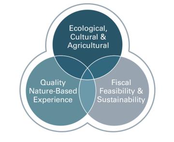
- Provide a quality outdoor recreational experience: A core service provided by LCDNR is nature-based public access to land that provides all visitors a chance to enjoy a natural outdoor setting supported with appropriate levels of infrastructure.
- Protect and enhance natural resource conditions: Concurrent with the provision of nature-based public access is LCDNR’s responsibility to protect and improve the intact integrity of natural and cultural resources. CHOS contains sensitive and important habitats and cultural features that will be protected and enhanced.
- Fiscal sustainability: To be responsible stewards of public funds and resources across the county’s open space system, LCDNR will strive to meet the first two objectives above while ensuring that management of the site is fiscally sustainable in the long-term.
Regulatory Context
Public Input
Larimer County began development of the CHOS management plan in early 2024, and throughout the year collected public input through a variety of ways on both an ongoing basis and at key milestones. This input was collected through a technical advisory committee, an online website, surveys, and public open houses. Feedback was also gathered from the 12-member citizen advisory boards for Open Lands and Parks, as well as the Larimer County Board of County Commissioners. Overall, nearly 1,400 respondents interfaced with the plan’s website including 471 survey respondents and nearly 600 comments from community members.
Technical Advisory Committee:
Public feedback opportunities
Through a dedicated project website, public input was collected via an online survey as well as an open forum comment board. Additionally, LCDNR staff hosted both in-person and virtual public open houses to collect additional input. These opportunities to provide feedback were shared widely through press releases, social media, newsletters, the project webpage, and technical advisory committee communications.
The first public meetings were held in spring 2024 to introduce participants to the project objectives, process and project website. The meetings were followed by a 2-month open survey to obtain general themes and preference on nature-based access to CHOS. Surveys were also sent directly to technical advisory committee and community organizations with an intention to collect comprehensive feedback reflective of the entire community, in particular from groups that may be historically underrepresented.
A second round of public input was conducted in the fall of 2024 to share proposed management concepts based on what the Technical Advisory Committee and the public identified as priority themes gathered from the first round of feedback. This second round of feedback included a Technical Advisory Committee meeting, a public meeting, and a second survey and input form posted on the website.
Public Input Priority Summary
Following the first phase of Technical Advisory Committee and public feedback, several themes emerged as preferred objectives and priorities for CHOS. These themes helped LCDNR determine management concepts for consideration before seeking a second round of more targeted community feedback. Themes included:
- Provide a high-quality trail system. Specific preferences for the trail system varied widely, but themes included a desire for connecting to Carter Lake, minimizing user conflict, providing a nature-based experience, and making trails sustainable.
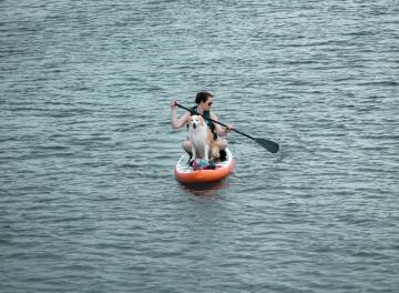
- Include meaningful access to the reservoir for all visitors, including access for fishing, swimming, hand-launched and trailered boats.
- Design parking to minimize crowding and include day-use amenities, particularly restrooms.
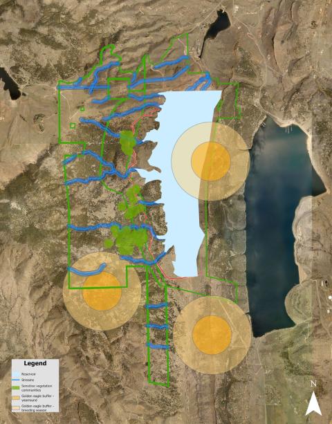
- Identify potential to improve ecological function & reduce habitat fragmentation.
- Protect wildlife habitat, avoid impacts to sensitive species.
Include opportunities for education, inclusion, and outreach.
Planned Management Actions
Based on the plan objectives and public feedback summary, management actions to improve visitor experience, enhance natural resource values, and maintain operational feasibility and sustainability, are described below. These management actions will be implemented between 2025-2027, after which time LCDNR will evaluate future management decisions against these objectives.
Management Zones
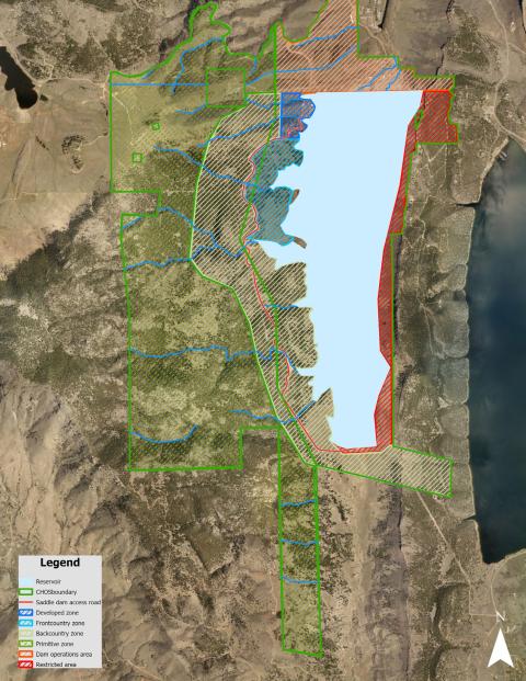
Management zoning is a key planning tool for making decisions about what is appropriate and not appropriate and what can and cannot occur in different areas within an open space in terms of resource protections, visitor use, facility development, and levels of service. Larimer County has long relied on the use of management zoning. The adopted management zones are summarized below accompanied by Map 1.
- The Developed zone is an area with major visitor facilities, (e.g. parking, trailhead, restroom, outdoor classroom, etc.). The sights and sounds of people and vehicles are generally prominent. The Developed zone may contain biological, cultural, geological, and/or other resources that require protection and management, but these are not easily disturbed by heavy public use.
- The Frontcountry zone is in an area that is predominantly natural, but with evidence of the presence of people. Most trail use by the public occurs in this zone. The only facilities are trails signs, benches, picnic areas, observation platforms, and service roads as appropriate. In this zone people can see, smell, and touch resources as they walk along a well-defined trail but will not feel like they are too far from their car or facilities. The Frontcountry zone may have biological, cultural, geological, and/or other resources that require protection and management, but these are not easily disturbed by regulated public use (i.e. public stays on designated trails, obeys regulations, etc.).
- The Backcountry zone provides a sense of being immersed in a natural landscape and feels further away from sights and sounds of other people and amenities. Visitors must commit a relatively high level of time and energy to access and be within this zone. The only facilities present may be unpaved trails, signs, benches, and observation platforms as appropriate. The Backcountry zone may have biological, cultural, geological, and/or other resources that require protection and management, but these are less easily disturbed by regulated public use (i.e. public stays on designated trails, obeys regulations, etc.)
The Primitive zone is an area where protection and management of ecological, geological, cultural, and/or natural resources supersedes other management actions. This zone provides landscape ecological integrity unfragmented by trails, roads, or infrastructure. No facilities or trails are present in this zone and, with a few exceptions, public access is limited. This zone in many cases adds to the quality of experience in other zones (e.g. scenery, buffer from adjacent land uses, opportunities for wildlife viewing) and is inter-related with those zones.
MAP 1
Parking and trailheads
To meet the objective of identifying appropriate public access and associated infrastructure, the following proposed management actions have been identified. These actions are intended to promote a quality visitor experience, support protection of the property’s conservation values, and be fiscally feasible for LCDNR to implement and manage into the future.
Parking & Access
Primary access to CHOS will be accommodated through construction of parking areas accessible from West County Road 18E and south of Carter Lake. The topography of the area along with cooperation with Northern Water are critical factors that guide the parking amenities described below.
Chimney Hollow Parking/Trailhead
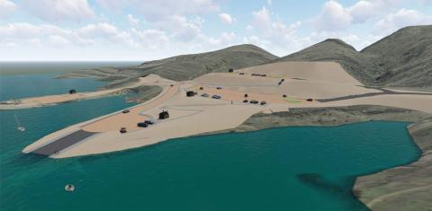
- Build tiered parking areas for public access to both the reservoir and open space.
- Upper tier – Approximately 40 single parking spaces (including ADA parking) to access the open space and trails.
- Lower tier – Approximately 55 single parking spaces (including ADA parking) and 20 trailer spaces to access the reservoir.
- Peninsula – Approximately 40 single parking spaces (including ADA parking), primarily for hand-launch watercraft access to reservoir.
- Include at each parking area, day-use amenities such as information kiosks, restrooms and picnic tables as appropriate and feasible.
- Evaluate opportunities for educational signs and programming.
Carter Lake Parking/Trailhead
Build an approximately 50-space trailhead parking area that includes 2-4 trailer spaces (including ADA parking), with a trail connection to the Sundance Trail at Carter Lake and connection into the trail system at Chimney Hollow Open Space.
Trail System
A quality trail system emerged as the highest priority of the public during the input phase. Considering this feedback, agreements with Northern Water, objectives to maintain habitat integrity and limit fragmentation, and metrics of other county open space trail to acreage ratios, the trail system at CHOS will be designed with the following characteristics:
- Sustainably built
- Experience driven
- Provide opportunities for enjoyment, scenic views, exercise, wildlife watching, well-being, and nature immersion o Include a total of 10-12 miles of primarily multi-use trails o Include a shoreline trail along the west side of Chimney Hollow Reservoir
- Provide loop options o Evaluate limited use and/or directional use
- Evaluate alternative trail sections adjacent to primary trails, using existing natural features. o Consider useability in design
- Exist within appropriate management zones including developed, frontcountry, and backcountry zones (Map 1)
- Connect to other areas o Include a trail connection to Carter Lake
- Consider future connections to other public lands or facilities
Reservoir Amenities
- Boat Access o Concrete boat ramp
- Floating dock
- Fishing access
- Shoreline trail
- Evaluate feasibility of a fishing pier
- Swimming access – Areas for safe open water access
- Reservoir zoning – Once the reservoir is complete and filled, access to the surface area of the reservoir will be zoned to consider visitor safety and appropriate uses. Potential zones include, but not limited to, swimming areas, boating areas, and restricted areas.
Accessibility amenities – evaluate day-use, fishing and boating access for visitors with disabilities including, but not limited to, parking, docks and trails.
Enhanced Ecological Condition
Habitat management actions will be prioritized to improve ecological conditions and resilience. Larimer County employs a variety of tools to manage habitat including, but not limited to, livestock grazing, forest health management practices, wildlife management, integrated weed management, and active restoration, all to encourage resilient native ecosystems.
- Vegetation management actions to meet ecological objectives include:
- Invasive plant and noxious week management
- Forest management o Monitoring rare and native plant communities o Evaluating the need for ecological restoration
- Evaluating the need for livestock grazing
- Monitoring and implementing closures as needed for nesting raptors.
MAP 2
Financial Sustainability
To provide a quality and consistent level of service to visitors and ensure long-term Departmental fiscal sustainability, a day-use fee will be assessed at CHOS. This fee will be in alignment with the existing LCDNR day use and annual permit fee structure. The determination to assess a user fee was informed by LCDNR internal financial modeling, consideration of nearby outdoor amenities, and projected staffing and management needs.
Conclusion
Conclusion Implementation of the management actions described above will take place over the next 1-5 years. Beyond that timeframe, management decisions will be based on criteria that emphasize improved visitor experience, enhanced ecological condition, and operational sustainability. In conclusion, the Larimer County Department of Natural Resources would like to express its deepest gratitude to all of the community members that contributed to the development of this plan.
Adopted March 10, 2025 by the Larimer County Department of Natural Resources.
Chimney Hollow Open Space - Adaptive Management Plan Access…
