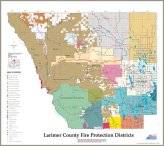
- Fire Protection Districts - This map identifies the fire department response areas for the 18 career and volunteer fire departments within Larimer County.
small: 800x700, 324Kb large: 2500x2200, 786Kb
- Wildfire Hazard Areas - This map identifies the wildfire hazard based solely on vegetation.
small: 800x700, 324Kb large: 2500x2200, 786Kb
- Wildfire Mitigation Area - This map identifies the designated Larimer County Wildfire Hazard Area.
small: 800x700, 324Kb large: 2500x2200, 786Kb
- Fire Plan Strategy - This map identifies fire categories that define the desirability of wildland fire in specific geographic areas with an emphasis on the wildland-urban interface.
small: 800x700, 324Kb large: 2500x2200, 786Kb
- Land Status - This map identifies ownership of lands within Larimer County.
small: 800x700, 324Kb large: 2500x2200, 786Kb
NOTE: The information on these maps is designed for general planning purposes. It is not intended for appraisal, engineering, legal or other purposes. Larimer County makes no guarantee as to the accuracy or usefulness of this information other than for its intended use by the Larimer County Planning Division. The Planning Division welcomes comments concerning the accuracy of the information depicted on these maps, in order to continually improve its database.
