Approved Lodging Facility Map FAQs
FAQs
-
What can I do with this map and how does it pertain to me?
Depending on if you are looking to renew, apply, voice a concern, or view approved Lodging Facilities in Residential Dwellings near you there are several options available to utilize this map.
- Using the map as an existing Lodging Facility Owner or Property Manager, you can see the expiration date, approval status, confirm if Property Manager contact information is up to date and then begin renewal processes by following the link to applications on our Lodging Facility in Residential Dwellings website.
- A Citizen, Peace Officer, Fire Official, etc., may use this map as a resource to review approved Lodging Facilities and how to voice questions or concerns through the Property Manager or Larimer County Code Compliance.
- Customers looking to apply for a Lodging Facility through a Planning process may operate basic searches for separation requirements and then contact Planning staff for further review and application options.
-
How do I correct my Property Manager information on this map?
If your Property Manager (P.M.) has changed there are steps to take to update the P.M. name and contact information with Larimer County, on guest documents, and for neighbors within 500 feet. The Community Information Resources Technicians (C.I.R.T.) can assist with contact changes for Property Managers and other important contacts associated with an approved Short-term Rental.
For contact changes we ask that you notify the Community Information Resources Technicians (C.I.R.T.) as soon as possible. Once C.I.R.T. is aware they will provide detailed instructions for updating the Property Manager or any other contact information changes necessary.
PlanningCIRT@co.larimer.co.us
(970) 498-7683 -
What if the Property Manager is not responding?
Code Compliance has options available to submit a concern via a 24-hour hotline or email. Visit the Code Compliance Enforcement tab on our Lodging Facilities in Residential Dwellings page for more information.
-
How accurate is this map?
This map is designed for informational purposes only, it is subject to change, and is not intended to be used as a final determination of eligibility. For specific questions about a property and the Land Use Code please reach out to the Planner on Call.
-
How do I use the map?
The Approved Lodging Facilities Map will open to a a basic function address search entry box at the top left hand corner. Below are some helpful instructions to navigate symbols on the map that may enhance your map experience.
To locate the Approved Lodging Facility Map key, navigate to the top right hand corner of navigation bar and select this symbol.

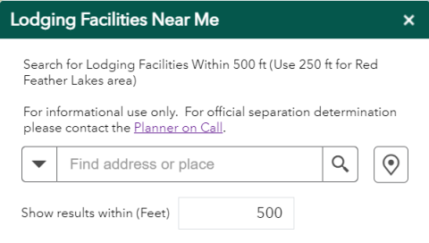
To access the "Near Me" by radius search box, select this symbol

located just under the main "Find address or place" search bar at the left hand corner of the map. This will open a new smaller window with a separate "Find address or place" search option for designated distances in feet from the specified address.

- If you have a specific address, use the "find address or place" search box.
If you would like to select a location on the map, first click this symbol

then click on the map in the location you would like to measure a radius distance from.
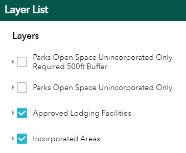
- Want to turn on the layer details for the Larimer County Parks and Open Space and the Parks and Open Space 500 Foot buffer?
Select the layer symbol

located at the top right hand corner of the map.
- A selection of optional layers will pop open like the example below.

- Select the check box of each layer you would like visible on the map. The blue check mark means it is on. Select the check box again to remove the check mark. This will remove the layer from the map.
