Frequently-Asked Questions
FAQs
-
What is aggregate?
Aggregate is crushed rock, gravel, or sand extracted from quarries and pits. You might hear it called “gravel” or “base course.” It’s necessary for building and maintaining roads. Learn more about how Larimer County uses aggregate for non-paved roads here: https://www.larimer.gov/roads/aggregate
-
Why is the project needed?
Larimer County maintains more than 400 miles of non-paved roads, and over 200 miles of those roads are in western Larimer County. These roads require a reliable and sustainable supply of aggregate to provide a durable, safe, and maintainable roadway surface. Roads in the Pingree Park area need new gravel and regular maintenance to remain safe and accessible for residents, emergency services, recreational users, and CSU Mountain Campus visitors.
This project is part of a larger strategy to develop small, geographically diverse aggregate quarries around Larimer County and closer to the roads they serve. Using small local quarries:
- Extends the life of the County’s Strang Pit for use along the Front Range.
- Reduces the need to haul gravel over 50 miles from the Front Range.
- Reduces impacts on Larimer County residents and roadway users by limiting transportation cost, long-haul truck traffic, roadway wear and tear, maintenance costs, and greenhouse gas emissions.
- Improves emergency response resiliency by having materials pre-staged and accessible at numerous locations.
-
Why was this site chosen for a quarry location?
Larimer County Road and Bridge worked with a consulting firm to identify potential quarry locations and screen each location through a rigorous process, shown below. After confirming all the factors required for a quarry, very few suitable sites remain across western Larimer County. This site meets all the criteria shown below, as well as its location in an area with a history of mining activity. Redeveloping an existing quarry reduces the impact on undisturbed land.

-
What is the alternative to this project?
Without this project, Larimer County would either haul aggregate from the Strang Pit in Eastern Fort Collins or purchase gravel from a commercial supplier on the Front Range. Both alternatives require long-distance hauling of aggregate, resulting in increased costs, traffic, greenhouse gas emissions, and wear on County roads. These alternatives are considerably more expensive and may not be financially viable. If the Project is not approved, the roads would likely remain at their current maintenance levels.
-
Why not use Larimer County's existing Strang Pit for all aggregate needs in Larimer County?
The Strang Pit is a vital aggregate resource for Front Range roads, but long-distance hauling of Front Range aggregate to Western Larimer County is inefficient, costly, and limits the lifespan of the Strang Pit. Developing small, geographically diverse quarries such as the County Rd. 44H quarry reduces costs, helps to extend the life of the Strang Pit, and limits the impacts of gravel production to the communities that directly benefit from road maintenance.
-
How does this project help in an emergency?
This project supports emergency response in two ways:
- Upgrading the roadway surfaces of Pingree Park Road, and portions of Buckhorn Road and Pingree Hill Road, improves driving conditions and decreases response times for emergency service vehicles in the event of an emergency.
- This project creates a local aggregate source that supports overall County aggregate resiliency. Having multiple, geographically diverse aggregate sources around the County allows the Road & Bridge Department to quickly respond and rebuild roads after floods and other natural disasters that could otherwise result in longer-term road closures due to access restrictions or lack of available materials.
-
What roads will be improved as part of this project?
This Project will focus on improvements to the following roads:
- Pingree Park Rd from HWY 14 to CSU Mountain Campus
- Pingree Hill (HWY 14 to intersection at Manhattan Rd.)
- County Rd. 44H west of the USFS Ranger Station
The Project may also provide aggregate for the maintenance of other roads, as needed

Map of Larimer County roads to be improved with gravel from CR 44H quarry. -
Does Larimer County get complaints about the condition of Pingree Park Rd?
Yes, the Road & Bridge Department receives complaints each year related to the roughness of the road, dust generated by roadway traffic, and snow removal. CSU staff support improving the road conditions for improved access and safety for students, staff, and Mountain Campus visitors. This project will improve the road surface and will enable Larimer County to provide a higher level of service on Pingree Park Rd., portions of Buckhorn Rd. and Pingree Hill Rd. as well as other nearby roads. Improving the roads will reduce the conditions that typically result in complaints.
-
Why doesn’t Larimer County pave Pingree Park Road?
While paving may seem like a straightforward solution to improve Pingree Park Road, the geography of mountain roads makes the process very complex and expensive. The general cost to convert a non-paved mountain road into a paved road is approximately $3M per mile. This includes mandatory upgrades to prepare for paving such as horizontal and vertical roadway realignment (straightening curves and adjusting slopes), creating stable roadway shoulders, and implementing measures to direct and control surface water. Once paved, it costs over $18,000 per mile annually to maintain the road. Given these high costs, the County is prioritizing maintenance improvements for Pingree Park Road and other nearby non-paved roads.
-
Will guardrail be installed along Pingree Park Rd. as a part of this Project?
Guardrails will not be installed as part of the roadway maintenance of Pingree Park Road. When considering the installation of new guardrail, the County must weigh the safety benefits guardrail provides against the constraints that guardrail imposes upon the County’s ability to maintain the road. In many cases, other improvements can improve safety without interfering with necessary maintenance activities. Guardrails tend to catch drifting snow and restrict snowplows’ ability to perform snow removal. They also constrain the working area for roadway maintenance activities.
-
Will Pingree Park Rd. be widened as part of this project?
This maintenance project does not include widening Pingree Park Rd. The intent is to improve road conditions of the existing alignment by adding a more maintainable and durable surface, not expanding or altering the roadway footprint.
-
What does this project entail?
The proposed Project includes expanding an existing gravel quarry on CSU property to supply aggregate for nearby County roads. The existing 2.5-acre quarry would be enlarged by approximately 9 acres. Quarrying would occur intermittently over a 15-year period, using Larimer County staff and equipment. After quarrying is complete the site will be revegetated and reclaimed to support future CSU Mountain Campus use of the area.
-
Whose project is this?
This is a Larimer County Road & Bridge project. Larimer County is collaborating with Colorado State University, which owns the land where the quarry would be located. The U.S. Forest Service supports the project due to its benefits related to roadway improvements, improved access for emergency service vehicles and recreational users, and because a portion of the existing quarry site will be reclaimed after project completion.
-
What will happen to the portion of the existing quarry that is owned by US Forest Service?
The existing quarry is bisected by a property boundary between CSU and the US Forest Service. Because sand and gravel mining are prohibited on US Forest Service lands within the Wild & Scenic River Corridor in this area, the Project will be contained on CSU property. No site disturbance related to this Project will occur on US Forest Service lands, including reclamation of the federally owned portion of the existing quarry.
-
Who is paying for this project?
The project would be funded through existing Larimer County Road & Bridge Department operating revenue. Funding sources for the Project are tied to Road & Bridge operating revenues. No new taxes or increases in fees are associated with this Project.
-
How much will this project cost?
Developing the CR44H Quarry is the most cost-effective way for Larimer County to produce and place aggregate needed for County Roads in the Pingree Park area. Because hauling aggregate long distances adds significant expense, producing material closer to roads to be maintained helps keep costs down. Preliminary estimates show that using aggregate from the CR44H quarry will cost about 20% less than it would to extract and haul aggregate from Larimer County's Strang Pit in the Front Range.
-
How long will this project last?
The Project is expected to last approximately 15 years. Quarrying will occur intermittently during that timeframe and will be subject to other obligations of Larimer County staff and equipment. Active quarrying would typically take place between June and October, depending on weather and staffing.
-
Once the roads are re-graveled, when would they have to be graveled again?
The life expectancy of a gravel road typically spans 12 to 20 years, though this varies based on traffic volume, traffic speed, road geometry, and environmental conditions. Roads with high traffic, high speeds, or steep, curvy alignments require more frequent gravel replenishment. Similarly, winter operations like snow plowing can displace aggregate and accelerate surface wear. To extend the intervals between re-graveling, the Road & Bridge Dept. uses routine grading and compaction to recover migrated material and maintain proper drainage. The application of dust suppressants and stabilizers further reinforces the surface, significantly prolonging the road’s durability.
-
How have CSU staff been involved in the Project?
CSU owns the property where the Project would be located. CSU Mountain Campus staff have been involved from the beginning of the Project, providing input on site layout and design, impacts to surrounding areas, and developing a vision for the future use of the site after the Project is complete. After quarrying is complete, the reclaimed site will support CSU Mountain Campus uses such as materials storage, overflow space, and outside classroom space.
-
Who will be working at the Site?
Similar to the County’s Strang Pit in eastern Fort Collins, Larimer County Road & Bridge staff will operate the quarry using County-owned equipment. The site will be regulated and inspected periodically by state and federal agencies.
-
What will the seasons and hours of operation be at the site?
Existing Larimer County staff and equipment would be used to operate the quarry, and those staff and resources are based at the County’s Front Range quarry. Mobilization to the County Rd. 44H site will require disassembly, transport, and reassembly of the crushing equipment. Due to the limitations on staff and equipment, quarrying at the County Rd. 44H site is not anticipated to occur every year. Operations are anticipated to be periodic throughout the 15-year project life. When the site is active, the hours of operation will be limited to standard weekday business hours. Operations will not occur between December 1 and April 30 to minimize impacts on migrating deer, elk, and moose that traverse between high and low elevations during this period.
-
What will happen to the site after the project is complete?
After quarrying is complete, the site will be reclaimed and revegetated. Quarry walls will be reshaped and reseeded with native grasses and forbs. The quarry floor will remain as a gravel surface to support future CSU Mountain Campus uses such as materials storage, overflow space, and outside classroom area.
-
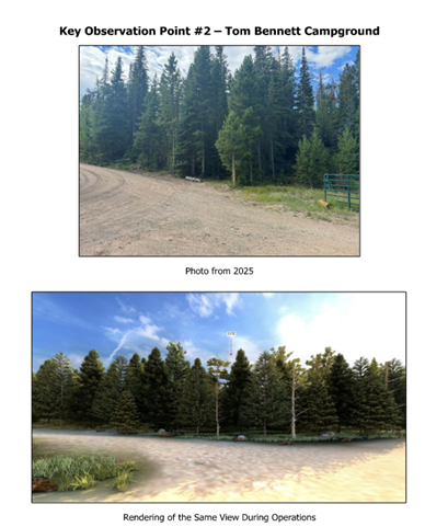
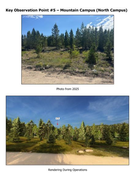
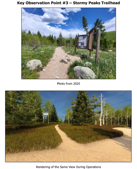
What will the impact of the Project be on neighbors, Mountain Campus Visitors, Stormy Peak Trail users and Tom Bennett Campground visitors?
Impacts are generally expected to be minor and temporary. The Project is designed to be obscured from popular nearby areas such as the Mountain Campus, Stormy Peaks Trail, and Tom Bennett Campground. Quarrying will usually happen between June and October, but the schedule may shift depending on weather and staff availability. Operations are not expected to occur every year. Instead, work will take place periodically throughout the 15-year project lifespan. When active, work hours will generally be standard weekday business hours. When inactive, the site will remain quiet and inaccessible. No work will be conducted on the weekends or between December 1 and April 30.
When in operation, daytime quarry operations will be audible from areas such as the Mountain Campus, Stormy Peaks Trail, and Tom Bennet Campground. An analysis conducted by a third-party consultant indicates that when the site is operational, the sound levels at nearby locations would meet residential thresholds for daytime exposures (per Colorado Revised Statute § 25-12-103). More information about environmental impacts and Larimer County’s environmental protection measures can be found here.
-
How far is the Project site from the South Fork of the Cache la Poudre River?
The river is approximately 800 feet (straight line distance) from the closest point of the Project footprint. Any water leaving the site would flow through historical flow paths off-site, to the roadside ditch, to two culverts that convey flows under Pingree Park Road. The total distance that water would travel from the site to the South Fork of the Poudre River is 3,000 ft.
-
What will the impact be to the South Fork of the Cache la Poudre River?
Surface water impacts on and off the Project site are expected to be minor. The river is approximately 800 feet (straight line distance) from the closest point of the Project footprint. The increases in 5- and 100-year stormwater discharge from the site are, on a watershed scale, minimal and will have no appreciable effect on the South Fork of the Cache La Poudre River. Temporary erosion control and stormwater management measures would be used to minimize erosion and runoff from the site, and to protect water quality.
-
What will the overall environmental impact be?
- Environmental impacts are generally expected to be minor and temporary. Impacts related to the following resources were evaluated by a third-party environmental consultant:
- Air
- Sound
- Cultural resources
- Traffic
- Recreation
- Visual resources
- Soil
- Wildlife
No protected species or habitat, riparian areas, or cultural resources would be affected by the Project. Larimer County has designed numerous protection measures into the Project to minimize impacts on the environment. More information about environmental impacts and commitments Larimer County has made to minimize those impacts can be found here.
-
Why is this project compatible with the Wild & Scenic River Corridor along the South Fork of the Cache la Poudre River?
This project is allowed because it is located on non-federal land owned by Colorado State University (CSU), where land-use guidelines differ from those applied to National Forest Land. While the Cache la Poudre Wild & Scenic River Final Management Plan prohibits sand and gravel mining on National Forest lands within the Wild & Scenic River Corridor, the Plan also protects the rights of all other landowners within the corridor to control their own property.
Larimer County and the US Forest Service (USFS) have collaborated on this project since approximately 2020, and the US Forest Service supports this Project at its current location in an existing inactive quarry. The USFS wrote a Letter of Support for the Project in 2024 (see below). Larimer County understands the importance of the Wild & Scenic nature of the river and has worked closely with the US Forest Service to gather and incorporate their input and design a project that aligns with values that prompted the river to be designated as Wild and Scenic.

-
How does this Project protect the "Outstandingly Remarkable Values" (ORVs) of the Cache la Poudre River?
The Wild and Scenic Rivers Act requires the protection of "Outstandingly Remarkable Values (ORVs)" in a designated wild and scenic river (https://rivers.gov/river/cache-la-poudre).
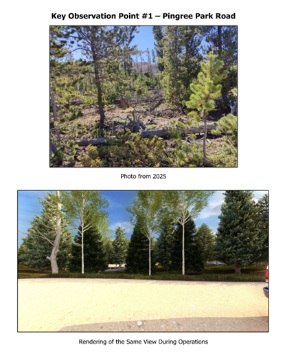
The 1990 Final Management Plan identifies scenic beauty and recreation as the primary values for this segment of the river. To protect these values, the project is located approximately 800 feet from the river and uses a persistent forest buffer to obscure the Project from nearby key observation points such as Pingree Park Road and the South Fork of the Cache la Poudre River. Anticipated operational noise levels have been modeled, and although the Project will be audible from offsite locations, noise levels will meet residential thresholds for daytime exposures (per Colorado Revised Statute § 25-12-103). Impacts to recreation are anticipated to be minor and temporary.
-
Will I be able to hear this Project from nearby locations?
Quarry operations will be audible from locations at the CSU Mountain Campus, Tom Bennett Campground, and the Stormy Peaks Trail during active operations. Due to Larimer County staff and equipment needs at other locations around the County, operations at the quarry are not expected to occur every year, but rather periodically over the 15-year project life. When active, operations would be limited to weekday daytime hours to reduce disturbance to those nearby. An analysis conducted by a third-party consultant indicates that when the site is operational, the sound levels at nearby locations such as the CSU Mountain Campus, Tom Bennett Campground, and Stormy Peaks Trail would meet residential thresholds for daytime exposures (per Colorado Revised Statute § 25-12-103).
-
How will dust be managed at the project site?
Dust at the Project site could be generated from equipment traffic, wind erosion, and the crushing operation. Dust would be managed through a combination of approaches that could include water trucks applying water to traffic areas, water spraying during dry or windy conditions, temporary seeding of topsoil stockpiles, and hydro-mulching of exposed ground. Larimer County will coordinate with the Colorado Department of Public Health & Environment’s Air Quality Control Division as part of the environmental permitting for the Project.
-
Will there be an increase in wildfire risk due to the project?
No there will not be an increase in wildfire risk due to the Project. The quarry will be operated with conventional excavation equipment and drilling and blasting will not be performed. Trees will be removed from the site during the early stages of the Project and there will be very limited fuel sources on site.
-
How will traffic on Pingree Park Rd. be impacted?
Traffic impacts related to quarry operations are expected to be minor and temporary. An analysis conducted by a third-party consultant indicates that weekday traffic could increase by 3.7% from current conditions during active quarry operations. This increase in traffic is related to County staff driving to and from the Project site during the weekdays. Hauling for roadway improvements will occur on an as-needed basis, as it would without the Project.
-
Will I be able to see this project from nearby areas?
A visual analysis conducted by a third-party consultant indicates that the Project site would not be visible from nearby key observation points, including Pingree Park Road, the Tom Bennett Campground, the Stormy Peaks Trail, Denny’s Point, and the CSU Mountain Campus. The site may be visible from more distant, higher elevation locations.
Below are examples of how the project would look from various observation points. Click an image below to enlarge.
-
What type of permitting is required to build this Project?
Before any quarrying can begin, Larimer County must undergo a thorough review and permitting process with State and County agencies. The project requires a 110 Construction Material Limited Impact Operation Permit from the Colorado Division of Reclamation, Mining, and Safety. A Location and Extent review is also required by the Larimer County Planning Department. Additional permits and review procedures will also be required by the Colorado Department of Public Health & Environment and Larimer County Planning. More information about permitting and regulatory approvals required for the Project can be found here.
-
Is Larimer County following Federal Regulations?
Yes, the Project will conform to all applicable federal regulations, such as the following:
- Wild and Scenic Rivers Act and the associated River Management Plan for the Cache la Poudre River
- Endangered Species Act
- Clean Water Act
- Mine Safety and Health Administration regulations
- National Historic Preservation Act
The Project will also conform to all applicable state and county regulations. Larimer County voluntarily conducted a thorough environmental impacts analysis as part of the assessment of the Project. Although the Project is not subject to the National Environmental Policy Act, environmental analysis of impacts was conducted in general accordance with the policy. Furthermore, Larimer County has implemented visual screening, erosion control measures, and a commitment to reclamation after operations are complete.
-
What is the regulatory oversight on this project?
- In addition to the thorough review and permitting process required prior to construction, the Project will be overseen by multiple agencies during operation. Site activities will be regulated by the Colorado Division of Reclamation, Mining & Safety (CDRMS), the U.S. Department of Labor's Mine Safety and Health Administration (MSHA), and the Colorado Department of Public Health & Environment.
- Colorado Division of Reclamation, Mining & Safety (CDRMS) ensures compliance with permit requirements, statutory standards and regulatory rules.
- Mine Safety & Health Administration (MSHA) regulates site activities and enforces safety and health rules for all mines in the United States.
- Colorado Department of Public Health & Environment regulates stormwater discharge and dust emissions from the site. Additional information on permitting and regulatory oversight can be found here.
- In addition to the thorough review and permitting process required prior to construction, the Project will be overseen by multiple agencies during operation. Site activities will be regulated by the Colorado Division of Reclamation, Mining & Safety (CDRMS), the U.S. Department of Labor's Mine Safety and Health Administration (MSHA), and the Colorado Department of Public Health & Environment.
-
Who can I contact to ask a question or provide feedback?
Email aggregate@co.larimer.co.us with any questions or requests for additional information. Also, continue to check this Project website for updates related to an upcoming Neighborhood Meeting or other opportunities for public comment during the permitting process.
QUESTIONS? COMMENTS? CONTACT US
ROAD & BRIDGE DEPARTMENT
PHONE: (970) 498-6052
Email us
