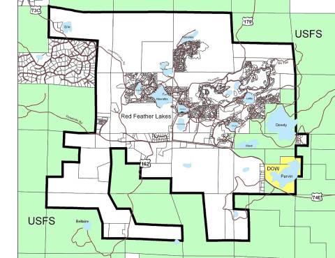
Since 2005, the RFL Area Plan has identified road maintenance as a priority community need. Identifying the centerline of village roads, siting their location according to known monuments, is the initial step in beginning a community dialogue to address ongoing road maintenance needs. Approximately 3.2 miles of roads within the Village were identified in this way in 2009 by Ayres Associates.
The new project would complete this process for the remaining 14.6 miles of roads within the RFL Village. With careful consideration of this potential project and its long-term benefits to the RFL community, the Larimer County Community Development Division is in support of working with the Red Feather Lakes community toward completion of this roads identification process.

Above is the Red Feather Lakes Area Plan as adopted in 2012. The proposed area of study for roads identification would encompass the area outlined in black excepting Fox Acres and the area currently served by General Improvement District 13A (Hiawatha Heights).
This process of identifying centerline road alignments is not an attempt by the County nor the PAC to prescribe road maintenance, but it may serve as a first step in community discussions to form some type of entity and/or process to foster ongoing, needed roads maintenance and other projects to further RFL’s vitality, safety, self-sufficiency, and quality of life.
As follow up to a 2010 roadway centerline survey, a new survey is to be completed covering remaining (unsurveyed) roads within the Red Feather Lakes planning area (area established through the 2005 planning process).
CENTERLINE SURVEY SCOPE
A. Locate 89 roads, with a total length of approximately 14.6 miles as identified in table (separate handout) provided by Lamp Rynearson. Locate edge of road on each side where road is of irregular width, and centerline where road is of a consistent width.
B. Locate property corners as observed along the roads.
C. Locate substantial obstacles within platted rights of way.
Brief History and Associated Documents
2022
Red Feather Lakes Centerline Project and Water Feasibility Study Community Meeting (6/4/22)
Red Feather Lakes Centerline Project and Water Feasibility Study Survey -
2019
Open House (7/12/2019) - Info Sheet
2017
A letter more fully explaining this proposal was sent to affected members of the Red Feather Lakes community - August 7, 2017.
In addition, a Road Study Proposal was provided by LAMP RYNEARSON (FC) in January 2017
- Proposed Roads to Be Surveyed (Table)
Also in 2017, a survey was conducted of the residents. of 739 letters and surveys sent, 233 individual responses were received - view survey results.
