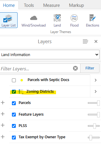
Step 1: Locate your property on the interactive map using the search bar
Step 2: Turn on the "zoning district" layer in the layer list (left hand side)
Zoning is a method used by local governments to create zones or areas for different types of land uses to provide separation between uses that may be incompatible. An example of this is having different zoning districts or areas for residential uses and for industrial uses.
Larimer County uses zoning districts to manage land uses and development of parcels in the unincorporated area of the county (outside of city or town limits). The zoning regulations also specify minimum lot sizes, minimum setbacks and maximum building heights. Click on the buttons below for more detailed information about zoning in Larimer County.
Additional Resources & Information
- County Assessor – For information about valuation and assessment of property and access to online property records and maps.
- Cities and towns in Larimer County – For links to cities and towns in Larimer County, as well as state agencies and other resources.


