WHAT'S HAPPENING AND WHY

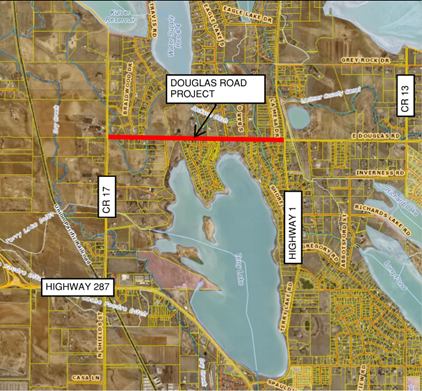
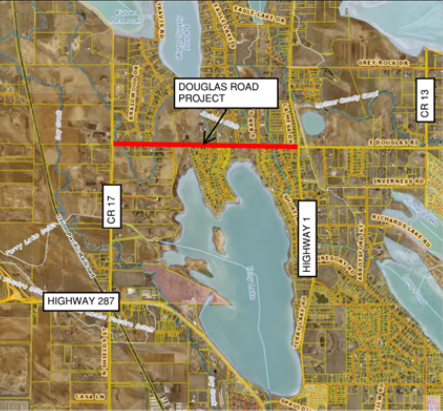
Larimer County has completed the preliminary design to address deteriorating pavement conditions on CR 54 (Douglas Road) and to add wider shoulders for bicyclists and pedestrians.  The preliminary design includes turn lanes to provide safer ingress and egress from homes and neighborhoods along the roadway.  The project limits will extend from CR 17 (Shields Street) to State Highway 1.

The project is currently on hold while funding sources are determined.

Send us your thoughts

PROJECT MAP

Map showing the section of Douglas Road involved in this project.

View larger map

PROJECT SCHEDULE


Image illustrating the proposed project schedule for the Douglas Road Safety Improvement Project. The schedule includes the following phases: preliminary design in 2024, right of way acquisition in 2025, and final design in 2026. The construction schedule is marked as 'to be determined.' The timeline is visually represented to show the sequence of these key milestones in the project’s development.

*The scope of work is dependent on funding availability. If full funding is not acquired, an overlay of the existing roadway will occur with no widening.

Besides overlaying the road, the proposed safety improvements include widened paved asphalt shoulders, and the addition of a center turn lane east of Swan Lane.  Existing culverts and irrigation ditch crossings will be improved to meet current standards.  The existing pavement section will be removed and replaced with new roadbase and asphalt.  Construction is anticipated to occur in 2026 or 2027 depending on funding availability.   

We understand that road construction can cause inconveniences including temporary delays.  However, access will be maintained to properties and subdivisions throughout the duration of the project.

Larimer County Engineering staff encourages you to reach out to us if you have any questions or concerns.


Diagram showing the typical roadway section of Douglas Road designed as a 2-lane arterial.

View larger image

Diagram showing the typical roadway section of Douglas Road designed as a 3-lane arterial.

View larger image

*The scope of work is dependent on funding availability. If full funding is not acquired, an overlay of the existing roadway will occur with no widening.

Open House Summary

37 people signed in and (4) comment cards were submitted.  The most common comments during the open house were regarding truck traffic, noise and speeding.  The majority of citizens seemed supportive of improving the pavement condition and the 6’ wide paved shoulders.  A portion of the citizens were in support of the 2-way center turn lane while others thought it was unnecessary.  Several people that could not attend the meeting have contacted us with similar concerns.   

Exhibits from Open House

The Douglas Road Conceptual Design Map shows the conceptual design for the Douglas Road Safety Improvement Project. The map includes highlighted sections of Douglas Road with proposed improvements.

Presentation board providing an overview of the project, including the identification of the road as an arterial in the Transportation Master Plan. The board outlines the project’s purpose, which includes addressing deteriorating pavement conditions, enhancing safety for turning vehicles, and adding widened shoulders to accommodate bikes and pedestrians. It also highlights efforts to minimize disturbance outside the existing CR 54 right of way and reduce impacts to adjacent properties.
Presentation board featuring a map that outlines the project area for the Douglas Road Safety Improvement Project. The map highlights the specific stretch of Douglas Road where proposed safety enhancements will take place.
Presentation board displaying key project elements for the Douglas Road Safety Improvement Project. The board includes details such as the construction of 6-foot wide paved shoulders, the addition of a 2-way center turn lane between Swan Road and State Highway 1, and the replacement of three ditch crossings. It also highlights the total estimated project cost of $7,500,000.
Presentation board displaying a map that outlines the parcels included within the project area for the Douglas Road Safety Improvement Project. The map highlights individual property boundaries and land areas that fall within the scope of the project. Parcel boundaries are clearly marked. The map provides a visual representation of how the project will impact specific parcels along the corridor.
Presentation board illustrating the road cross sections for Douglas Road at two key segments: between CR 17 and Swan Lane, and between Swan Lane and State Highway 1. The cross sections show the proposed layout and design of the road, including lane widths, shoulder dimensions, and center turn lane.
Presentation board listing key traffic and road design details for the Douglas Road Safety Improvement Project. It includes current daily traffic of about 4,500 vehicles per day and a projected 2040 traffic volume of 9,300 vehicles per day. The board also highlights the average weekday traffic count of 122 large vehicles in 2024, a speed limit of 35 mph, and proposed improvements such as a widened curve radius for westbound right turns and northbound right turns at the Shields Street and Douglas Road intersection. Additionally, it outlines the plan for a continuous 2-way center turn lane between Swan Road and State Highway 1.
Presentation board illustrating traffic counts for total average daily vehicles and average daily large vehicles on Douglas Road. The board compares traffic data from several years: in 2018, there were 4,654 daily vehicles and 150 daily large vehicles; in 2020, 3,807 daily vehicles and 74 daily large vehicles; in 2022, 4,373 daily vehicles and 76 daily large vehicles; and in 2024, 4,851 daily vehicles and 122 daily large vehicles. The visual representation shows the changes in traffic patterns over time, highlighting trends in both total vehicle counts and large vehicle traffic.
Presentation board listing frequently asked questions (FAQs) for the Douglas Road Safety Improvement Project. Please see the FAQs at the bottom of this web page for further information.
Presentation board illustrating the proposed project schedule for the Douglas Road Safety Improvement Project. The schedule includes the following phases: preliminary design in 2024, right of way acquisition in 2025, and final design in 2026. The construction schedule is marked as 'to be determined.' The timeline is visually represented to show the sequence of these key milestones in the project’s development.
Presentation board displaying information on how to stay connected with the Douglas Road Safety Improvement Project. Contact details for Clint Jones, Project Manager, are provided: email at cdjones@larimer.org and phone at 970-498-5727. The board also includes a link to find project updates at Larimer.gov/Engineering.


  1. Truck traffic continues to increase, and trucks utilize unmuffled jake brakes and speed regardless of the signage. What can Larimer County do to reduce the number of trucks?  Can Larimer County restrict truck traffic? 

    CR 17, CR56 and Douglas are all mainline county roads, and we do not have the option of restricting trucks.  Contacting the Sherriff’s department is the best way to deal with speeding concerns and use of unmuffled jake brakes (the number is 970-498-5357)

  2. Will widening the shoulders and adding the center turn lane draw more traffic to the area?  Is the center turn lane needed?

    Traffic will increase regardless of whether we make these improvements or not and it has been our experience that these types of improvements do not attract additional traffic.  The road widening addresses current safety concerns and provides additional capacity for all road users (bikes, pedestrians, and vehicles).  The Larimer County Urban Area Street Standards, and Rural Area Road Standards were used to determine the need for the 2-way center turn lane.

  3. How will the road work impact my property?

    We will try to minimize impacts to private property, however in some cases improvements will extend outside the existing right-of-way causing fences to be reset and trees may need to be removed.  We will work with individual property owners to minimize impacts to their property and to acquire any additional any additional right-of-way that is needed on a case-by-case basis.

  4. Sight Distance at Swan Lane is very bad.  Will sight distance be improved with the project?

    We are somewhat constrained by steep grades, driveway tie-ins, and wetlands adjacent to the road.  We will improve sight distance as much as possible while minimizing the impacts to mature trees and wetlands, however we may not be able to improve the sight distance as much as we would like to.

  5. Douglas Road is very steep approaching County Road 17.  Can you soften the grades to prevent people from sliding through the intersection in poor road conditions?

    We cannot change the grades approaching the intersection because of the Jackson ditch crossing. As we continue with the design, we will look for other ways to improve safety at the intersection.

  6. When will the project begin?

    The project is still not fully funded so the soonest construction could begin would be 2026.

  7. How long will the project take to construct?

    8-12 months with utility relocations happening ahead and during road construction.

  8. How will I access my home during construction?

    There may be delays during construction; however, we will maintain access for the duration of the project.  Detours from the east and west may be needed during various phases of construction.

  9. Douglas Road currently has no passing for its entirety and should remain that way.

    Passing restrictions will remain as they are today.

  10.  Will the Speed limit increase?  Can you decrease the speed limit to 30?

    The speed limit will remain 35 mph.  We have no plans to lower or raise the speed limit with this project.