Alexander Mountain Fire recovery information.
Larimer County joined the National Flood Insurance Program (NFIP) in 1974 and has been managing floodplains ever since. The county uses floodplain standards and maps as the main tools in its Floodplain Management Program.
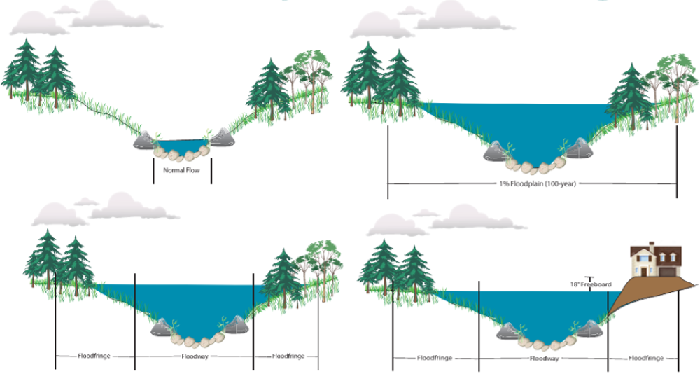
In Larimer County, development in the Floodway is heavily restricted. New buildings cannot be built, and major changes to existing structures are not allowed. There are fewer restrictions in the Flood Fringe areas.
Identifying floodplains
The County’s interactive map can help you find out if your property is in a regulatory floodplain. Just enter your address in the search box or zoom to your area.
FEMA’s Map Service Center is another useful tool.
Remember, even if your property is not in a regulatory floodplain, it doesn’t mean there is no flood risk. Many areas in Larimer County are not shown in a floodplain but still have unknown flood hazards.
If your structure is in the floodplain
The NFIP allows property owners to buy flood insurance. If you have a mortgage or loan, you will be required to have flood insurance if your property is in a Federal Emergency Management Agency (FEMA) floodplain.
Floodway vs. Flood Fringe

Colorado Hazard Mapping Program (CHAMP) Portal
The State of Colorado has studied and mapped flooding through the "Colorado Hazard Mapping Program (CHAMP)." This state-funded program helps update flood risk maps, especially in areas affected by the 2013 Colorado floods. It uses detailed methods to assess flood risks.
 Interactive Floodplain Map
 Larimer County Floodplain Regulations
 Flood Review Board

