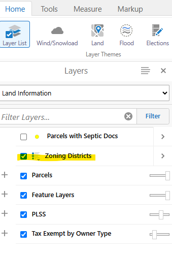
Step 1: Locate your property on the interactive map using the search bar
Step 2: Turn on the "zoning district" layer in the layer list (left hand side)
Zoning Parcel Search
FAQs
-
What is my zoning?
You can find the zoning for a specific property in the unincorporated area several ways:
- Locate your property on the Interactive Map (hint: use search bar in upper right corner) and then turn on the "zoning districts" layer on the layer list menu.
- Use the Assessor's Property Search Tool to find your property. (Hint: After selecting a property, click 'View on GIS Map'. Under the Layer List menu on the map, click on the checkbox for Zoning Districts.)
- Contact the Planning Department - To verify the zoning district for a particular property, contact the Planning Department via email. Please be prepared to provide an address or parcel number to identify the property.
-
What is the difference between zoning and how the Assessor classifies property?
These are two different designations, but they are sometimes confused with each other. Each parcel of land in the unincorporated area of Larimer County is zoned. Parcels also have a property tax assessment classification assigned by the County Assessor to classify, assess and value property.
- Zoning districts are adopted by the Board of County Commissioners. The zoning district determines the uses that are allowed on a property. Article 2.0 of the Larimer County Land Use Code contains the zoning regulations. For more information on zoning districts in unincorporated Larimer County, see the Zoning Districts page. Contact the Larimer County Planning Department at by email for assistance with your zoning questions.
- Property tax assessment classifications are determined by the County Assessor's Office based on the actual use that is present on a property. That classification is shown in the Assessor's property records for each parcel. For more information about assessment and valuation of property, contact the County Assessor's Office at (970) 498-7050.
The property tax assessment classification is not the same as the zoning district for your property.
-
What things does Larimer County regulate with the zoning district?
The purpose of zoning districts is to implement the Larimer County Comprehensive Plan, promote compatible land use patterns and establish standards appropriate for each zoning district. Each zoning district spells out the uses allowed on properties within that district, the minimum lot sizes, the maximum density allowed if a property in that district is developed, the building setbacks required from property lines, heights for structures, and accessory uses allowed.
-
What are the building setbacks for my zoning district?
Each zoning district in the County lists setbacks from streets or roads, side, and rear property lines. Additional setback requirements are found in Article 2.0 of the Land Use Code.
Property owners and citizens are advised to contact the County Planning Department for setback information on specific properties due to the many factors and unique situations that affect setbacks. To confirm setbacks on your property, contact the On Call Planner via email.
-
Are there setbacks from streams, creeks, and rivers?
Yes. The minimum required setback from any stream, creek, or river identified on a U.S.G.S quadrangle map is 100 feet from the centerline of the water course unless a greater setback is required by Article 4.4.2. Wetlands, Article 4.4.4. Wildlife, or Article 12.0, Floodplain, or unless evidence is provided documenting that the centerline has been relocated by a previously approved development, or where the centerline is a ditch managed by a ditch company. This setback is not applicable to irrigation laterals.
Contact the On Call Planner via email if have any questions or would like to begin the process for a variance or minor modification request. -
What are the uses allowed in my zoning district? Where can I find the regulations for each zoning district?
Article 2.0 of the Land Use Code provides more information about each specific zone district.
To find out which uses are permitted in your zone district, check out the table of allowed uses. The tables are organized by urban and rural zone districts, and the Estes Valley.
(Blank cells = prohibited use)If you would like to begin a planning process for one of these uses, please reach out to the On Call Planner via email.
-
What are overlay zone districts?
In addition to the zoning districts that exist for each property in unincorporated Larimer County, there are also overlay zone districts that apply in certain areas. These are described in Article 2.7 of the Land Use Code. Overlay zone districts have development standards and requirements that apply in addition to those of the underlying zone district.
One of these overlay zone districts is for the official floodplains which designate areas of the County where flooding may occur. The requirements of the floodplain overlay zone districts are intended to reduce flood danger. Contact Larimer County Engineering staff at (970) 498-5700 for more details.
Other important overlay zone districts designate Growth Management Areas (GMAs) in the areas around the cities of Fort Collins, Loveland, Timnath, Berthoud and Windsor. These overlay districts provide regulations to guide development near the participating communities and help to facilitate cooperative growth management in urbanizing areas of the county.

Larimer County Planning Division
200 W. Oak Street, Third Floor, Fort Collins, CO 80521
On-call Planner:
Email the on call planner - planning@larimer.org
OR
Leave us a detailed voicemail - (970) 498-7679